 The GWE Program's
Water Resource Sustainability work includes two
cooperative studies with the U.S. Geological Survey
(USGS) Nevada Water
Science Center:
The GWE Program's
Water Resource Sustainability work includes two
cooperative studies with the U.S. Geological Survey
(USGS) Nevada Water
Science Center:
Evapotranspiration (ET) Study
-
ET definition
-
Perennial yield
in the Amargosa Desert hydrographic area may
have been underestimated by as
much as 28,000 acre-feet in previous USGS
studies
-
Evaluate ET rate
over bare soils where depth to water is less
than 50 feet
-
Study will be 3-5
years, depending on ET rates determined in the
first year of data collection
Southern
Amargosa eMbedded Model (SAMM)
-
"Daughter model"
to Death Valley Regional Flow System Model will
allow evaluation of pumping scenarios at fine
scale in the Amargosa / Ash Meadows area
-
Grid size in the
Death Valley regional flow system model is 1,500
x 1,500 meters; grid size in SAMM is 500 x 500
meters
-
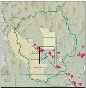
In the figure
(upper right), the Death Valley regional flow system
model boundary (green line) and boundary for
SAMM (black line) are shown. Proposed
renewable energy developments, as of April 2009,
are shown in magenta. [Figure from Belcher
and Bright, 2009].
BACKGROUND
Evapotranspiration (ET) Study: Numerous studies by
the USGS have been conducted to estimate groundwater
recharge and discharge in the Death Valley regional
groundwater flow system. These estimates
assume that springs and seeps contribute only
minimally to groundwater discharge, and that the ET
rate from unclassified areas and non-vegetated areas
are negligible. Nye County contends that
significant discharge does occur in these areas
where the depth to water is less than 50 feet (these
areas total approximately 90,000 acres).
Depending on the groundwater discharge rate applied,
as much as 28,000 acre-feet of discharge may have
been overlooked in the previous studies. To
address Nye County's concerns, a 5-year study has
been proposed by the USGS to characterize
groundwater discharge in the areas identified by Nye
County as having significant groundwater discharge.
SAMM: The SAMM is a groundwater flow model
constructed by the USGS that is a "daughter model"
of the much larger Death Valley regional groundwater
flow system model developed cooperatively by the
Yucca Mountain Project and National Nuclear Security
Administration 9NNSA). The SAMM will rely on
inputs from the regional model and refines the
geologic and hydrologic grids (over a small area) to
simulate groundwater flow and the effects of
geologic structures more accurately than possible
with the regional model. Funding for the SAMM,
as well as the data used to construct the model is
derived from multiple sources, including the USGS,
Nye County, the USF&WS, NPS, DOE and BLM. The
model will serve as a common tool for these
agencies, and others, to simulate the potential
effects of pumping groundwater under various
scenarios.
SPECIFIC TASKS
-
Recharge Evaluation.
This study will consist of 1 - 3
years of direct measurement of ET losses
from areas of shallow groundwater.
After the initial year of data
collection the study may be terminated
if the ET rates are found to be very low
(implying very limited groundwater
discharge).
-
Perennial Yield Evaluation.
This task is complete. Results are
documented in Parks, 2010 thesis titled:
"Analysis
of Electromagnetic and Seismic
Geophysical Methods for Investigating
Shallow Sub-surface Hydrogeology"
-
Impact Evaluation.
Development of a finer-scale model domain
for the embedded model, including Ash
Meadows, Amargosa Farms area, Devils
Hole, and Stewart Valley; linking the
embedded and regional models; and tandem
calibration of the shared model domains.