GWE
DRILLING PROGRAM BACKGROUND
Water
level data from the NWRPO Water Level Measurement
Program (WLMP) have been used to identify spatial
trends (rises and declines) throughout southern Nye
County and portions of Clark County, Nevada and Inyo
County, California.
Several data gaps were
identified during this analysis, particularly in
three areas:
-
On the alluvial fan area in Pahrump.
-
Down gradient from previous nuclear tests
on the Nevada Nuclear Security Site.
-
In the northern Amargosa
Desert.
GENERAL OBJECTIVES
-
Infill data gaps
in the water level measurement program
-
Better understand
geologic controls on ground-water flow
-
Determine aquifer
characteristics
-
Provide data to
assist Nye County Water District with basic
water resource characterization in southern Nye
County
SPECIFIC OBJECTIVES
There
are three (3) primary tasks with the following specific objectives:
-
Groundwater Conditions in Pahrump Valley.
Five (5) boreholes and wells
to infill data gaps in the WLMP,
especially on the Pahrump Fan.
-
Water Resource Conditions in Amargosa Desert.
Seven (7) boreholes and
monitoring wells to: 1) collect
baseline flow and chemical data south and west
of the Nevada Nuclear Security Site, and 2) determine head
relationships near the Gravity Fault to help
determine the role of the Gravity Fault in
restricting or facilitating groundwater flow in
the Amargosa Valley.
-
Surface Water Conditions in Southern Nye County.
Two (2) boreholes and
monitoring wells in
Oasis Valley to collect baseline flow
and chemical data in areas (far) down
gradient from previous nuclear tests.
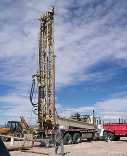
DRILLING
PROGRAM
Fourteen boreholes were drilled by Hydro Resources,
Inc. for a total of 4,600 feet
(locations
are shown on the GWE Well map).
The drilling was completed in two phases between May
2010 and January 2011.
Drilling Parameters:
-
All boreholes are located on existing Early
Warning Drilling Program (EWDP) sites or on privately-owned
lands
-
Air foam, conventional circulation methods were
used
-
10-inch surface casing set to 20 feet, 8-inch
borehole drilled to total depth
-
Boreholes were drilled to approximately 100 feet
below the water table
-
The shallowest borehole was OV-2 (119.8 feet);
the deepest was PV-1 (610 feet)
Monitor Well Completion Parameters:
-
Wells completed with 4-inch Schedule 80 PVC
-
Sandpack and grout were emplaced using tremmie
methods
-
Surface completion with protective steel casing,
concrete pad, and locking well cap
DATA COLLECTION
Borehole Data Collection Parameters:
-
All data are collected under the NWRPO Quality
Assurance Program
-
Cuttings samples were collected every 5 feet
-
Sediments were logged using Unified Soil Classification System descriptions
-
Consolidated rock was logged using quantitative
descriptions
-
Borehole geophysical logs were collected
-Open-hole (gamma, resistivity, temperature, and
caliper)
-Completion (gamma, temperature, fluid
resistivity, and density)
Pump
Testing Parameters:
4-inch casing limited pump tests to 3-inch pumps
resulting in low flow rates and very little
aquifer stress.
Step testing
Constant discharge testing
DATA
As
Water Resource Characterization and Monitoring data
packages and publications are completed, they will
be made available for
download.
Each completed well will include
well completion diagrams, summary geologic information, pump test data, water
chemistry, and water level data.