![]()


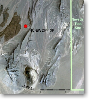
Well No. NC-EWDP-13P SITE SUMMARY
Status: Completed.
Latitude/Longitude (Datum is NAD-83):
36o 44' 39.866" North
116o 30' 50.235" West
Legal Description:
Township 14S, Range 48E, Section 13, SW 1/4 SE 1/4Elevation (Datum NGVD-29):
895.35 meters AMSL (2,937.50 feet) GPSAccess: From the junction of Highways 95 and 373, drive 9.7 miles west on Highway 95 (just west of mile marker 40). Turn north and proceed through the gate 2.6 miles over a dirt road to where the road forks. A this fork, follow the eastern road 2.1 miles north to the drill site.
Purpose: NC-EWDP-13P was designed to serve as a hydrogeologic exploration borehole to approximately 1,559 feet below ground surface and to serve as a monitor well with a single screen extending across the water table. Primary technical objectives include: 1) collection, geological logging, and laboratory testing of nearly continuous drill cutting samples; 2) borehole geophysical logging of the geologic formations penetrated; 3) use of these data to define the stratigraphic sequence and to better characterize geologic structural boundaries immediately south of the proposed repository; and 4) permit the collection of water level and water chemistry data from the uppermost aquifer.